Welsh 3000’s
On the 7th June 2021 I attempted to complete the mammoth walk over all 15 Welsh 3000ft peaks in a single walk with several friends. This is my journey…
Pen-y-Pass to Car Park north of Foel-Fras
Distance: 51.5km (32 Miles)
Time (Car to Car): 25 Hours 40 Minutes
Time (Peak to Peak): 21 Hours 42 Minutes
Ascent: 3620m (11,877ft)

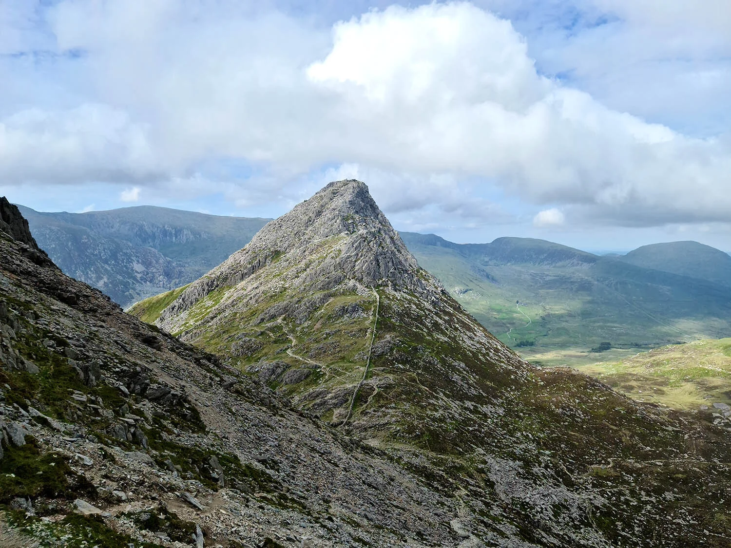
Sunrise from the slopes of Crib Goch
Having set up our transport system the day before (e.g. leaving one vehicle at the end of the walk and arranging a taxi from the middle) we arrived at the top of Pen-y-Pass at 04:04am having had only 5 hours of broken sleep due to the anxiety of what was to come. The ascent starts right from the car park and follows a path to the base of Crib Goch. The sun had already started to rise making us think we could have started a bit earlier than we did…
The view back down to Pen-y-Pass was breathtaking. The golden sun slowly rising over the Glyders on the other side of the valley and the thick cloud clinging onto the summit of Snowdon and Garnedd Ugain. Upon reaching the base of Crib Goch there’s a solid 300m of rocky scrambling to reach the summit, all of which was easy enough and meant we were at the knife edge within 30 minutes.

The cloud clinging to Y Lliwedd and Yr Wyddfa (Snowdon).
There are several summits to Crib Goch, the first being 921m and the highest point being the second at 923m. It’s likely at this time in the morning you may cross other walkers doing the Welsh 3000s as the right on the right heading north is a common route of descent down to Llanberis Pass. This was a possibility for us right up until the day before when we opted for the Llanberis Path and a little footpath that curves round the mountain and arrives at the road near Nant Peris. The reason for the last minute change of plan was because we had originally considered doing a walk that took i the scree slope as a descent to ‘test’ it out and make sure we were all happy to head down this way. Sadly we didn’t manage to do this walk and after measuring both routes, the Llanberis Path way was only 1km longer and as it was a simple path the whole way we thought it might actually be quicker.

The north ridge of Crib Goch.
We carefully treaded the route across the spectacular knife edge that was Crib Goch. Never have I been on such a spectacular ridge before. In the Lake District there are several well known edges, these being Striding Edge and Sharp Edge. Crib Goch is much more like Sharp Edge but probably 10 times longer and with a bigger drop on both sides! It’s truly spectacular and one I will certainly be coming back to do again and again!

Crib Goch.
The second pinnacle is the true summit of Crib Goch at 923m with the third being slightly lower at 914. The crossing was a little greasy in places where the rock is beginning to wear down and the damp morning dew certainly didn’t help the situation but once across it’s a simple and easy scramble up to the summit of Garnedd Ugain at 1065m.

Silhouetted crossing of Crib Goch.
It was a bit longer than I thought to get to Garnedd Ugain and once we got there the summit was in thick cloud. It was about 2 hours 44 minutes to this point and we’ve now ticked of 2/15 peaks.
The path to Snowdon was a simple one to follow but sadly we remained in the clag the whole time with no photo opportunities except for evidence of reaching the summit at 07:14am. We refueled here, having a good breakfast and the started the long descent to Nant Peris along the Llanberis Path.
We must have passed around 50 people heading up Snowdon along this path, compared to only 10 or so on the Crib Goch route and managed to find the faint route off the Llanberis Path and around a peak called Derlwyn. Although faint the path probably saved us half an hour compared to going all the way to Llanberis itself and after about 15 minutes on the road we arrived at Nant Peris for a toilet break and water top up (for those unaware the public toilets at Nant Peris have a water tap too! Very useful!)
We took a good 15 minute break here, taking the boots off and letting the feet air a bit as the next section of ascent is a big one! I don’t have a time for when we arrived here but I estimate it to be around 09:30am.
We headed out of Nant Peris and began the solid 800m of ascent up the side of Elidir Fawr. Once you cross the stream over the new footbridge the ascent is continuous… relentless… and damn steep the whole way… Literally a 1 in 3 for about an hour…
It was hard work but we managed to get to the summit in good time, stopping only twice on the ascent and reaching the summit at 11:56am.

A sheltered lunch spot on Elidir Fawr.
Feeling rejuvenated and in good spirits knowing we had done one of the biggest sections of ascent on the entire walk, we continued to follow the path around Foel-Goch and up a another 200m of ascent to Y Garn at 947m. The view from the top of Y Garn allowed us to see a majority of the next few miles, with the Glyders over to the east, Tryfan directly across the valley and Llyn Ogwen down below (when the van was parked!)

We sat for 10 minutes on Y Garn to have some more food and make sure out feet were feeling Ok for the next ascent which involves 290m of up, 200m of which are on steep loose scree.

The summit of Y Garn looking to Tryfan and the Glyders.
The ascent to Glyder Fawr was not as bad as I thought it was going to be. It was hard work but I managed to keep going and we arrived on the summit at 15:17., almost an hour after leaving Y Garn. Glydar Fawr is an awesome mountain, just scraping the 1000m contour at its summit which is crowned with jagged sharp rocks. I’ve always known the Glyders are popular mountains… now I know why…

The summit of Glyder Fawr.
The path between Glyder Fawr and Glyder Fach is barely traceable on the ground simply because of the rocky nature of the mountain and nestled between the two peaks is the 972m rocky outcrop called Castell Y Gwynt meaning ‘Castle of the Wind’. We decided on passing the outcrop to summit it as part of our Welsh 3000s route even though it is not officially part of the 15 due to its lack of significant prominence being just 15.7m above the surrounding plateau.

Castell Y Gwynt.
A simple ramble across the rocky plateau leads to the outcrop called Glyder Fach at 994m above sea level and back on track for the official Welsh 3000s. Due to our exhaustion we didn’t stay long at the summit, instead choosing to sit out of the wind on the northern side before contemplating out risky descent. The most direct route is to follow a 'path’ along the side of Glyder Fach’s northern ridge which connects it to Tryfan. I had never been along this path before but Tim and Megan had and both said it was incredibly steep and loose underfoot making me slightly apprehensive.
We chose to head over and have a look, with the option of continuing east to pick up the Miners Track and head to Tryfan if we changed out minds. We all agreed to take it nice and easy on the descent down the steep scree and although it was loose underfoot it again was not as bad as anticipated. Usually sections of path like this are worse in the mind than in reality.
This is where we had out first accident…
Tryfan on the descent of Glyder Fach.
Sorry for the cliffhanger there as it wasn’t a serious accident, far from it! Tim was descending just above Megan and myself and managed to slip on the loose scree causing him to break one of his trusty walking poles. How minor this may sound it actually made us think is it still possible to continue the whole walk without two pole each?
A little note on Walking Poles. This was the first walk I have ever done with them and I would have to say I’m not sure I could have done the distance or ascent without them!
We continued down to the col between Glyder Fach and Tryfan and took a scrambly path up to the Adam and Eve, two tall rocks marking the summit of Tryfan and sat for a few minutes having a snack. It was now 17:35 and we had been walking for 13 Hours and complete two of the three great mountain ranges.

Adam and Eve, Tryfan.
We plodded down the Mountain, continuously thinking of how sore our feet were and how exhausted we all were. We passed a beautiful mountain lake where I had stopped at the other day for some lunch and proceeded down to the Van where we had plenty of water and food prepared and took a good long rest.
I think we must have sat around here for over an hour, rehydrating, eating plenty of food to the point where eating was no longer pleasurable and just a necessity for fuel. We chatted amongst ourselves, building the psych again to just get up this last big section of ascent. We told ourselves if we just managed to get up Pen yr Ole Wen then that is most of the ascent then completed and its just ‘little bits between the peaks’. This was encouragement enough for us all to go for it and we set out around 20:30 knowing we had around 10 hours to get to the final peak to complete the route in the time frame of 24 hours.

The sun setting on Tryfan.
The path up towards Ffynnon Lloer (a small mountain tarn) was not the most obvious but some footpath work had been completed thanks to the National Trust but the going was Ok taking just one rest until we reached the ridge leading to the summit. The path was rocky in places but nothing harder than what we had done earlier that day and the ascent was quick.
Just 200m below the summit my mind snapped and I was temporarily a broken man. My energy levels were at an all time low, I had lost the ability to walk properly and almost unable to stand on my feet. The feeling hit me like a truck, being fine one moment to being absolutely done the next. Encouragement spurred me on and we finally reached the 978m peak of Pen yr Ole Wen at 22:19 as the sun was setting and a sudden and unexpected burst of renewed energy came over me thinking “That really is the hardest bit done.”

Megan enjoying the Sunset on Pen yr Ole Wen.
This is where things became a little trickier and planning really comes into its own.
If we had started the walk an hour or two earlier, started in the dark and arrived at Crib Goch just as it was getting light then we would have that extra daylight here to aid navigation.
Alternatively if we went up the Miners or Pyg Track to Snowdon and got there just as it was getting light. e.g. start at around Midnight for a 2am summit of Snowdon, then we would again have more light on this section as light really affected out ability and motivation here.
The walk around to Carnedd Dafydd at 1044m above sea level was simple enough and light was still acceptable but as we reached the summit the headtorches were needed (we used the Red Light to maintain any night vision we had).
The 3km to Carnedd Llewelyn was one of the toughest yet mentally. Due to the lack of views it was very hard to judge the distance to the next peak but a silhouette of it could continuously be seen, taunting us. The path was mediocre and involved a lot of little ‘ups and downs’ making us feel more exhausted than before and most people completing the route would take a narrow path contouring Carnedd Llewelyn to head over to Yr Elen first. Due to light we didn’t have this choice and instead went to Carnedd Llewelyn first and at 1064m it was the third highest peak of the entire walk.
This is where the exhaustion level reach a whole new level in all three of us. We seriously contemplated abandonment of the challenge for a minute but made out way down towards Yr Elen.

Carnedd Dafydd
We had a few issues at this point. Neither of us had ever been on Yr Elen before or know the way up to the summit. It was dead of night now with no moon (Make sure you do this on a full moon - it will seriously help night navigation), and what we could see of the route up appeared to be very rocky and a possible scramble. This is where Megan’s head torch started to play up and turn itself off with no warning too.
We sat on the side of Carnedd Llewelyn for about 15 minutes, discussing if we should attempt it in the dark, not knowing anything about it and knowing that half way up (if it was a scramble), Megan’s torch may fail putting her at risk of falling.
Logic would say turn back, but when you have just walked around 40km just to get to this point and not be able to continue can make you think illogically. It was at this time, probably around 01:30am at a guess that we decided to me safe and not progress onto Yr Elen and make our way north along the mountain range to Foel Grach.
We were three experienced hill walkers and made the right decision in a bad situation. It was here I made a promise to come back and do this again once we have recced Yr Elen at some point in the future. This decision, even though it was the right thing to do, broke our spirits. We had worked so hard to get here and only fail just at the end…

Sunrise the following morning
It’s amazing how your mind can play such a big role in your ability to complete such mammoth tasks like the Welsh 3000s. Our spirits were broken due to failing on Yr Ellen but what broke us even more was the fact we still had around 6 miles left to go to get to the car… We had abandoned the 3000s but still had to complete the distance!
We summited Foel Grach at 976m but decided to try and save a minimal bit of energy by navigating around Carnedd Gwenllian (926m) as we had failed the 3000s by this point. Thinking back it probably would have made no difference whatsoever if we summited this one or not as we still had to follow the wall to the final peak of Foel-Fras at 942m of which we arrived here within the 24hour window from peak to peak with time to spare (enough time to have done Yr Elen) which meant we would have succeeded if we didn’t bail at that moment.
It was only 5.7km down from Foel-Fras back to the car. The mental and physical side of being ‘Broken’ has many layers and this was a path of discovery. Discovering that we could be even more disheartened and broken than we were before. 5.7km has never and will never feel so far ever again (unless I do actually do this walk again…)
Every step was like running a marathon. Our feet felt like we were walking on a bed of nails and broken glass (although I had no blisters!). Our energy levels were at an all time low and the slog down actually felt torturous. Never in my life had I ever felt or thought that I would ever want to be off a mountain so quickly but the car could not get here soon enough. The views were undeniably spectacular during the Sunrise but our minds were barely functioning to even realise. This was by far the toughest 5km of my life and made me reconsider the promise to complete the 3000s again in the future.
I’m not going to lie, it was hard work, very hard. Absolutely the hardest and most demanding walk of my life. Imagine doing a decent mountain walk and how tough it can be, well this is like doing that 3 times in a row. The strange thing about this walk is that now I am looking back just a few weeks later, having recovered, I’m looking back with fond memories and sheer proudness that I managed to complete the route we set out (minus two peaks) and managed to walk 51.5km (32 Miles) and ascend almost half the high of Mt Everest in a single day.